Khaberni - The regional "Arab Weather" center announced an upgrade in the classification of the upcoming low pressure system to the fourth degree (highly effective) which is the penultimate degree in the innovative classification scale for weather depressions designed by the center.
The upcoming depression has been named "Benevolent Depression".
The upcoming depression is considered exceptionally rainy and will provide a strong boost to the rainy season, God willing.
Reason for Upgrading the Classification of the Depression
The classification of this depression was upgraded due to several reasons, the most important being the expectation of significant rainfall of more than 100 mm in various parts of the north and center of the kingdom, leading to strong flash floods and extensive water flow in valleys, in addition to a significant expected drop in atmospheric pressure values at the center of the depression causing fierce and stormy winds to blow across the kingdom on Tuesday, especially in the south and east of the kingdom.
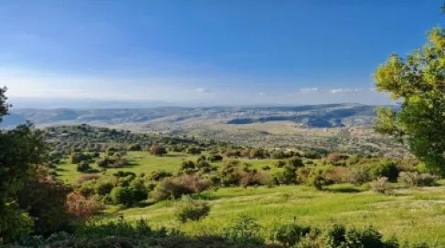
Simulation results also indicate expectations of snowfall on the high mountain elevations in the north and center of the kingdom, including the high mountains of Jerash and Ajloun and mountain peaks in Balqa and Amman, which will later extend during the evening and night of Tuesday/Wednesday to the peaks of the Shara mountains.
Timeline of the Depression:
Monday night, a highly effective cold air front
A highly effective cold air front is expected to cross the north of the kingdom just before midnight, accompanied by heavy rainfall, thunder, and hail showers, which may be intense over the high mountainous areas.
In the hours after midnight, the passage of the air front continues to reach the central areas, accompanied by very heavy and continuous rainfalls, leading to strong floods and large water flows in valleys, and these rains are accompanied by thunder and dense hail showers.
Low clouds touching the elevated surface of the land cross the mountainous highlands, leading to fog formation and reduced horizontal visibility.
The effects of this air front reach the eastern regions of the kingdom as periodic rainfalls, while the southern regions of the kingdom remain unexposed to the rainfalls.
At the same time, strong southwesterly to westerly winds blow, with intense gusts in some areas, which may lead to dust waves in the desert areas.
Tuesday: The kingdom continues to be affected by the depression
A noticeable drop in temperatures occurs on Tuesday, with temperatures being colder than usual for this time of year by about 5-7 degrees Celsius. The weather will be cold in general areas and very cold in the high mountain ranges, and it will be stormy, cloudy, and rainy by God's will in the north, center, and east of the kingdom, extending the rains to the Karak governorate. The rains will be heavy and accompanied by hail showers, which can be intense at times, especially over the high mountain ranges.
Also, it is not ruled out that there will be snow showers in the morning hours, which may sometimes accumulate on the peaks of the high northern, central, and mountain ranges that include the peaks of Jerash and Ajloun mountains and the mountain peaks in Balqa and the capital Amman.
In the afternoon hours, it is expected that the precipitation will reach parts of the Tafilah governorate, appearing as snow showers over the peaks of Qadisiyah and Rashadiyah.
Fierce winds will blow across the kingdom, ranging from southwesterly to westerly, strong in most areas with stormy gusts, especially in the south and east of the kingdom, which will lead to dust and sand on the outer desert roads and border crossings (especially those not experiencing rainfalls).
Tuesday night/Wednesday:
The weather depression moves northeast, and the effects of its aftermath continue to impact the kingdom by God's will, especially on the southern highlands
The weather will be generally cold in various regions, and extremely cold in the high mountainous areas, cloudy and stormy with periodic rain in parts of the north, center, and east of the kingdom, as well as parts of the Karak and Tafilah governorates and the western highlands of Ma'an, with the rains accompanied by hail showers occasionally.
It is expected that the precipitation will be in the form of snow showers over the peaks of the Shara mountains, including the peaks of Rashadiyah and Qadisiyah in the Tafilah governorate, and the peaks of Shobak, the Petra district, and the southern Taibeh and western Ma'an governorate.
And fierce winds are expected to blow over the Shara mountains in the south of the kingdom, estimated to reach speeds exceeding 110 km/h, which requires readiness and attention, while the winds are active to strong in general areas, with strong gusts at times.
Recommendations:
• Be aware of strong flash floods and large water flows in valleys, as well as rising water levels in wide areas of the north and center of the kingdom.
• Be cautious of the dangers of rockslides on steep slopes.
• Be cautious of the danger of high wind speeds, which may reach speeds exceeding 90 km/h in accompanying gusts, and reduce vehicle speeds on outer roads, and secure outdoor belongings.
• Be cautious of the risks of slipping on roads due to the intense fall of hail over the high mountain ranges, especially the higher ones.
• It is necessary to be cautious of the risks of reduced horizontal visibility on mountain roads due to fog or dense precipitation.
• Ensure safe use of heating devices.
• Avoid crossing valleys even if water levels are not high.
• Drive carefully on roads that may experience snowfall.
• Drive carefully on outer desert roads and border crossings due to dusty conditions in areas not experiencing rainfall.