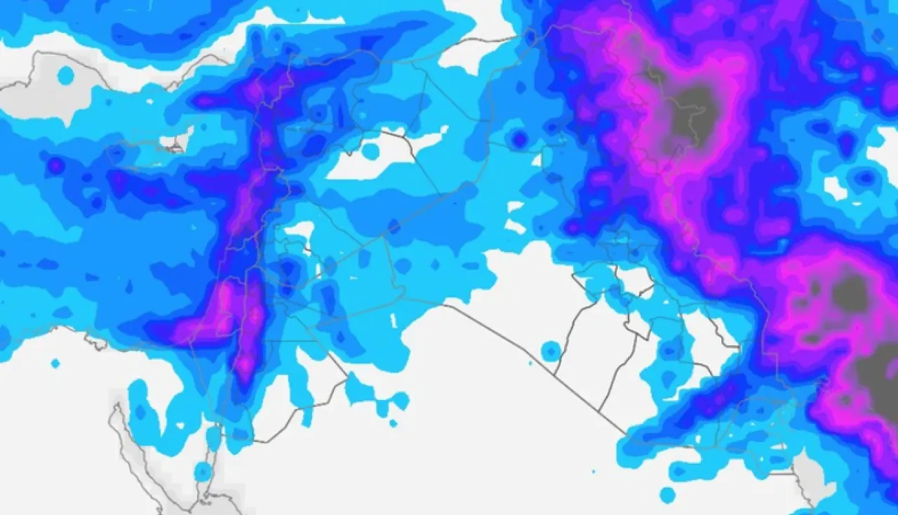
Khaberni - The latest outputs of the computer simulation maps indicate the formation of a new air depression over the eastern basin of the Mediterranean, gradually centering on Monday 29 December 2025 north of Syria, affecting the Kingdom by God’s will as a third-grade air depression (medium to high impact)..
This depression is characterized by being fast-moving and short-lived, yet effective in terms of rainfall and winds. Heavy rain is expected, especially in the north of the kingdom, along with strong winds in the southern and eastern regions..
Details of the weather condition and the impact of the air depression on the kingdom
Monday morning and the start of the day: Very cold weather prevails in all regions, with clouds appearing at various altitudes, and rain showers falling intermittently, concentrated in the north of the kingdom and extending to parts of the central regions..
Monday noon and afternoon: A cold air front crosses the kingdom and peaks the impact of the depression
The impact of the air depression gradually intensifies, and a high-effectiveness cold air front crosses the kingdom starting from the north, turning the skies completely cloudy, regularizing the rainfall, and expanding its scope from the north to the center. The rains will be extremely heavy, with chances of lightning, thunder, and hail, which could lead to:
Streamflow of valleys and gullies
Formation of floods including the northern valleys
Water accumulation on roads
Also, low clouds touching the ground pass, causing the formation of dense fog over high mountainous elevations, leading to a significant reduction and possibly a disappearance of horizontal visibility on some roads..
The arrival of the air front to the south of the kingdom during the afternoon and evening
During the afternoon and evening hours, the passage of the cold air front completes across the kingdom, extending its effects to the south of the country, including the governorates of Karak and Tafila and the southern valleys, where heavy rainfall is expected to increase the risk of valley streamflow and floods, possibly causing soil and rock landslides in the affected areas. Concurrently, the winds become noticeably active in::
Plain regions
The desert
Southern highlands
Strong winds accompany the crossing of the air front
The winds will be strong, with gusts ranging between 90–100 km/h, leading to dense dust waves in the eastern desert, including the Baghdad International Road..
Monday night/Tuesday: The air depression moves quickly away from the kingdom and its impact gradually declines, with continued chances of scattered rain showers, particularly in the southern regions, along with cold weather..
Summary and classification of the air depression
* Classification: Third-grade (medium – high impact)
* Duration of impact: Fast (about 15 hours)
* Period of impact: From Monday morning until Monday night/Tuesday
Expected rainfall amounts: 25 – 90 mm
Wind gusts speed: 90 km/h and may exceed this locally
Temperature range: Between 4 – 10 degrees Celsius
Snow: Not expected
Important recommendations during the weather condition::
* Wear warm clothing especially during nighttime and early morning hours.
* Safe use of heating devices.
* Drive cautiously and maintain a safe distance during rain and fog.
* Be aware of the danger of floods and flowing valleys, especially in low-lying and southern areas.
* Beware of soil and rock landslides, particularly in the southern highlands.
* Be cautious of dense fog and reduced horizontal visibility on external roads.