



Khaberni - The United Nations General Assembly approved on Friday a resolution supporting the adoption of a world map that shows the size of Africa more accurately, in culmination of a recent campaign led by African countries and activist groups. The resolution, sponsored by Togo and supported by members of the African Union, was endorsed by 164 countries, with a single opposing vote from the United States, while Serbia, Estonia, Georgia, Lithuania, Moldova, and Ukraine abstained from voting.
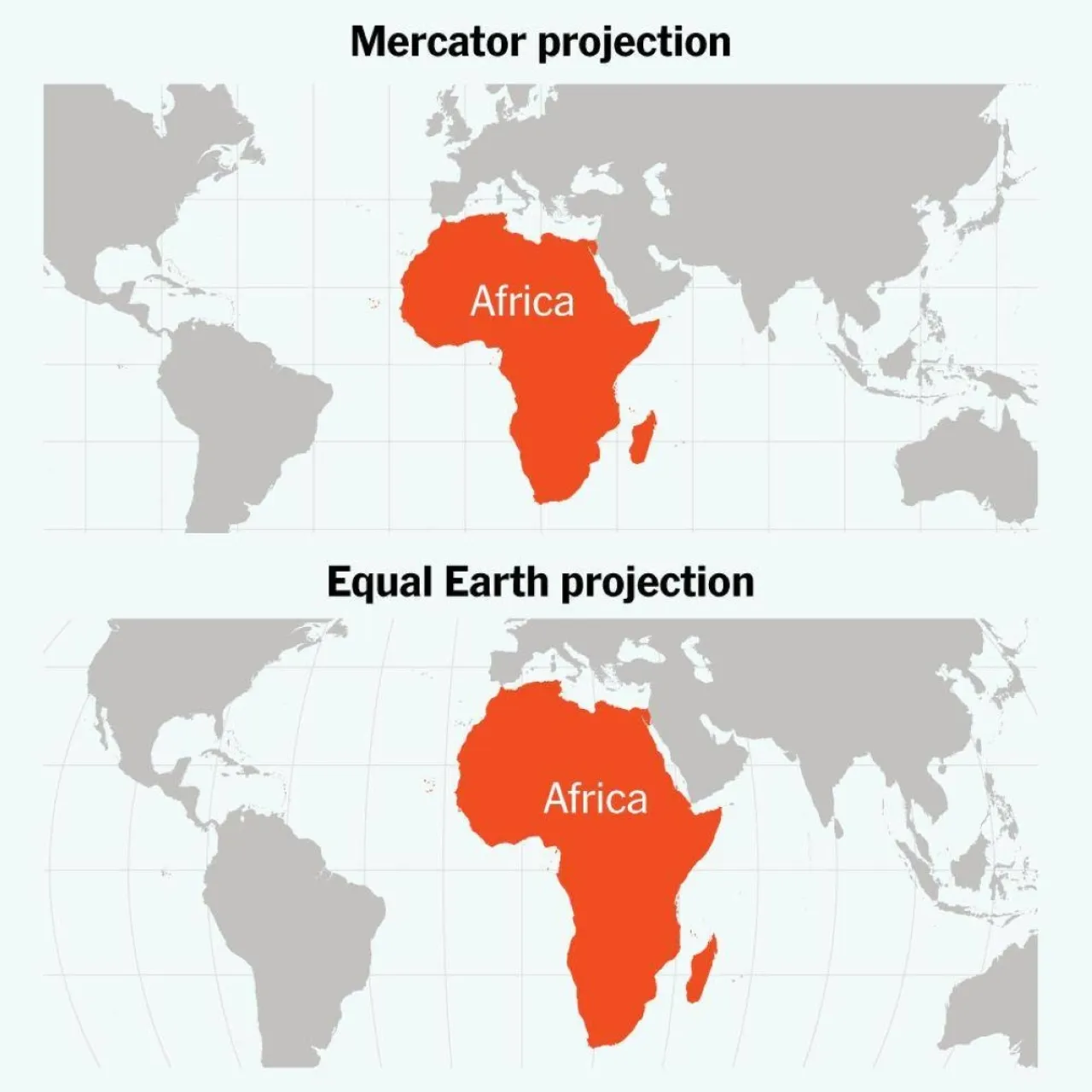
The resolution encourages governments and institutions around the world to replace the traditional «Mercator» projection, which has been widely used since the 16th century, with the «Equal Earth» projection, which depicts the continents’ sizes more accurately. On the Mercator map, Greenland and Africa appear similar in size, whereas in the «Equal Earth» projection, Africa appears about 14 times larger than Greenland, but the resolution is not binding, meaning it does not require map companies to change their systems immediately.
However, the impact of this step might extend beyond textbooks and traditional maps, reaching «Google Maps» relied on by millions of people daily; does this voting mean that the world we see on our phone screens will change, and will Google abandon the «Mercator» projection in favor of a map that shows Africa closer to its true size?
Why does Africa appear smaller than it is?
The problem lies in the nature of the «Mercator» projection, which was invented by Flemish cartographer Gerardus Mercator in 1569 to aid sailors in navigation. Despite its success in this use, it distorts sizes as areas move away from the equator.
Because of this distortion, regions in the northern hemisphere appear much larger than their actual size, while Africa and areas near the equator appear smaller. One of the most famous examples is that Greenland appears on the map about the size of Africa, despite Africa being about 14 times larger.
Indeed, the vast area of Africa theoretically allows the United States, China, India, Japan, Mexico, and a large part of Europe to fit inside it, with room to spare.
Who is behind changing the map?
Togo was at the forefront of efforts to change the way the world is drawn, with support from the African Union. The campaign, named #CorrectTheMap, attempted to address what African countries see as a persistent distortion of the continent's image in global maps.
The campaign believes that the problem is not just visual, but that maps that downsize Africa and equatorial regions could have a long-term impact on education, culture, geopolitical and economic perceptions.
Before the vote, Togo's Foreign Minister Robert Dussey said that the issue is not political but scientific, emphasizing that there is scientific evidence of distortion caused by the Mercator projection.
What is the new map?
The alternative pushed by the campaign is Equal Earth, a design that emerged in 2018 and was developed by an international team of cartographers. This map preserves the correct proportions of continental areas, making Africa appear much closer to its actual size compared to Mercator.
This does not mean that the new map will appear tomorrow on every phone or screen; the UN resolution does not impose an immediate change. However, the vote may encourage educational institutions and technology companies to reconsider the maps they use.
France begins already
France not only supported the resolution but also announced through its Foreign Minister Jean-Noel Barrot that it would abandon the Mercator projection, moving to maps that are more suitable for its uses and more faithful to actual land sizes.
France will use the Eckert IV projection, which is similar to Equal Earth in its focus on representing areas more accurately.
Will Google Maps change?
As for «Google Maps», it is unlikely that the map appearance will change immediately, as the UN resolution does not compel technology companies to adopt «Equal Earth». However, Togo is preparing to host an event in the capital Lomé during the first quarter of next year, with the participation of UNESCO, the African Union, and several technology companies, including «Google Maps», to discuss ways to implement the resolution and encourage the use of more accurate maps in representing the sizes of the continents.
Thus, what happened is not a «redrawing» of Africa's borders or a change in its area, but an attempt to change the image in which the continent appears on the world map.
While the Mercator projection has been used for about five centuries, supporters of the resolution believe it is time for a map that shows the world as it truly is, not as it appears due to geographic projection distortions.