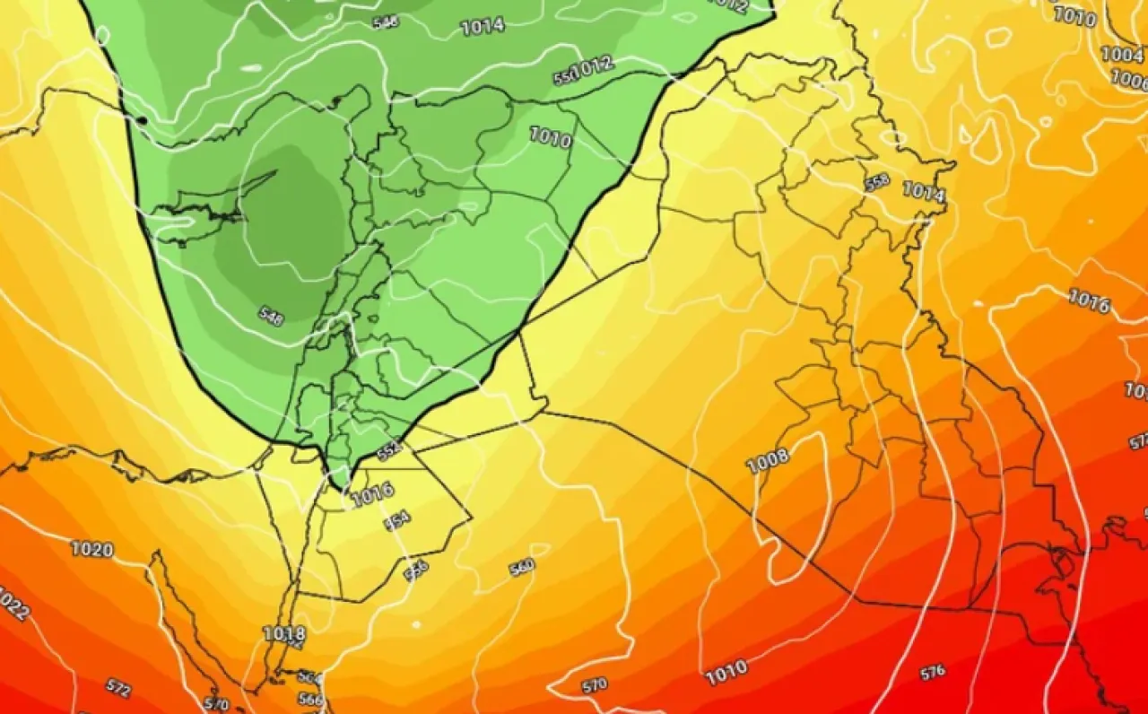
Khaberni - The latest outputs of the Arab Weather's computer simulation models indicate that the kingdom, God willing, will be affected from the noon hours of Friday 9 January 2026 by a new air depression classified as third degree (moderate to high effectiveness) according to the Arab Weather's innovative weather depression intensity scale. The rainy winter weather returns to various areas of the kingdom due to this air depression, God willing, where it is expected that heavy rains will fall at intervals, accompanied by lightning and thunder and hail showers, especially during the evening and night hours, leading to the formation of floods and running wadis, and rising water levels in a number of areas.
The impact of the air depression is preceded by a period of stable weather, peaking on Thursday 8 January 2026, when temperatures will be several degrees Celsius above the general averages and pleasant and moderate weather will prevail during the afternoon hours, with maximum temperatures approaching 20 degrees Celsius above the mountainous highlands, including parts of the capital Amman, while exceeding the mid-twenties in the Jordan Valley, Dead Sea, and Aqaba areas, before significant and noticeable changes in the weather occur on Friday.
The computer simulation outputs indicate a sharp change in the weather with the noon and afternoon hours of Friday, where the kingdom gradually becomes affected by an air depression classified as the third degree, accompanied by a noticeable drop in temperatures compared to Thursday. The weather will be notably cold with the appearance of medium and high clouds from the morning hours, and the possibility of local scattered rain showers in some areas.
During the noon and afternoon hours, the southwest winds gradually intensify and are accompanied by strong gusts that may cause dust storms in the eastern desert regions, in preparation for crossing a cold air front. As the front crosses, rain-bearing cloud quantities increase, starting with rainfall in the north of the kingdom, then extending to the central regions including the capital Amman, and later to the eastern regions and southern highlands, including the governorates of Karak and Tafila.
The rainfall will sometimes be heavy, and may be accompanied by thunder, lightning, and hail, increasing the risk of wadi runoff and the formation of floods and rising water levels on many roads.
The kingdom continues to be affected by the air depression throughout Friday night/Saturday, where very cold, cloudy, and rainy weather prevails in several areas, especially the eastern and southern regions. The rains will be heavy at times, leading to the flowing of valleys and gulleys and the formation of floods, possibly causing soil and rock displacements. Low clouds also cross, touching the ground surface, leading to the formation of dense fog over high mountainous elevations.
Additionally, the wind speed intensifies markedly on the southern highlands, becoming very strong and accompanied by gusts that may reach or exceed 100 km/hour, especially on the peaks of Shara mountains, while they are active to strong in other regions.
Summary and classification of the air depression
Classification: Third degree (moderate to high effectiveness)
Impact period: About 24 hours (from noon Friday to noon Saturday)
Expected rainfall amounts: 20–80 mm
Affected areas: Most areas of the kingdom
Wind gusts speed: 80 km/hour, exceeding 100 km/h in Shara mountains
Temperature range: Between 2 and8 degrees Celsius
Key recommendations during the weather event
Beware of the danger of floods and running wadis especially in low-lying areas and usual flood formation sites.
Caution against landslides of soil and rocks, especially in the southern highlands and areas of slopes and valleys.
Secure outdoor possessions due to the intense wind activity, particularly in the southern highlands of the kingdom.
Wear warm clothing, especially during night and early morning hours.
Safe use of heating appliances.
Drive carefully and maintain a sufficient safe distance during rain and fog.